In our previous articles, we explored the realm of spraying drones, understanding their functions, applications, and even highlighted specific models like Terra Agri spraying drones designed for pest management. Today, our focus shifts to another intriguing facet of agricultural technology—agriculture mapping drones. This innovative practice is gaining considerable traction, especially in technologically advanced countries.
Unveiling Agriculture Mapping Drones
Agriculture drone mapping involves the use of unmanned aerial vehicles equipped with advanced cameras and sensors. These specialized drones capture high-definition images from above, creating intricate maps of farmlands and other agricultural areas. The information derived from these maps serves a multitude of purposes, ranging from monitoring crop health and planning irrigation systems to surveying for pests and evaluating topography.
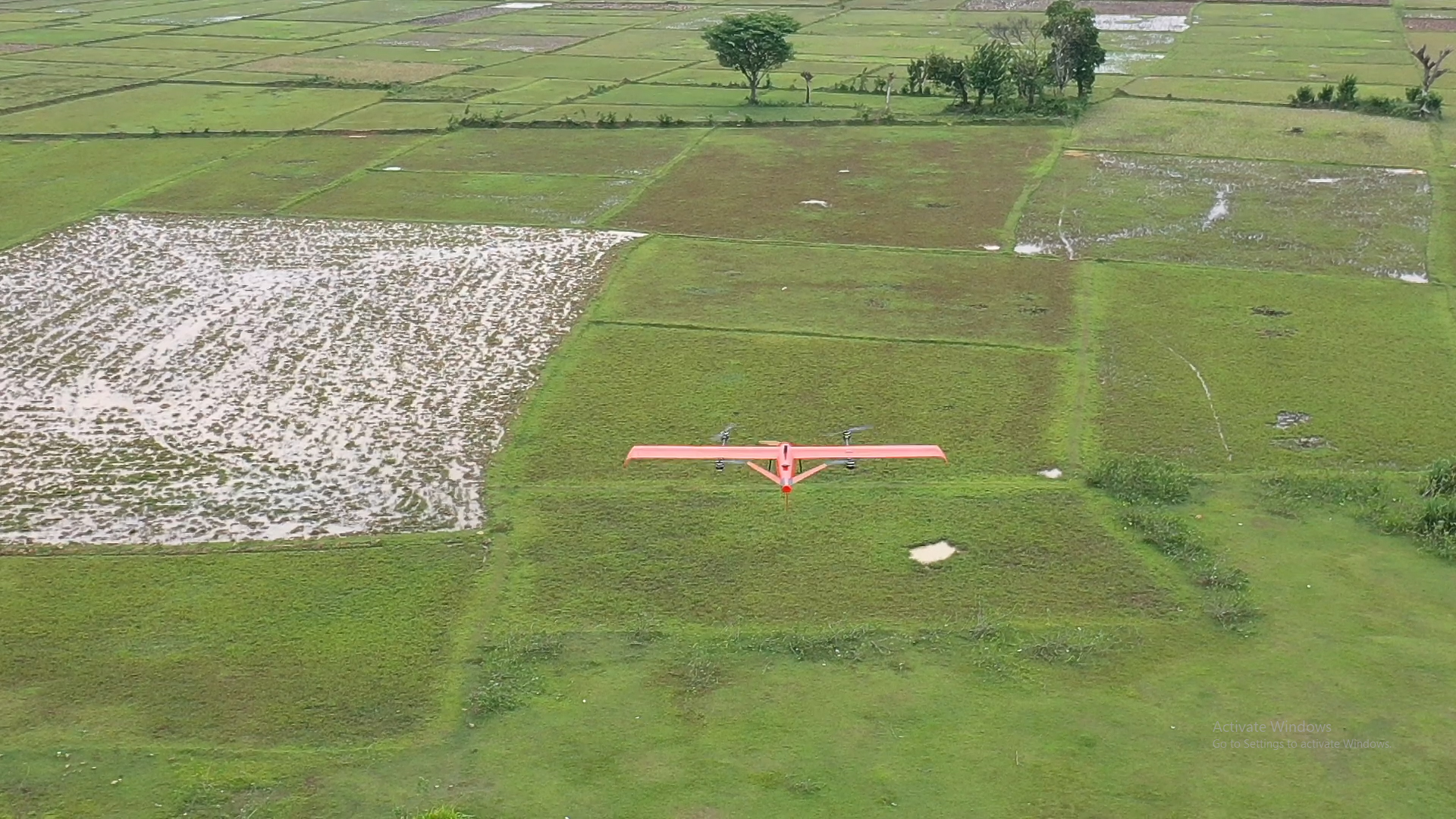
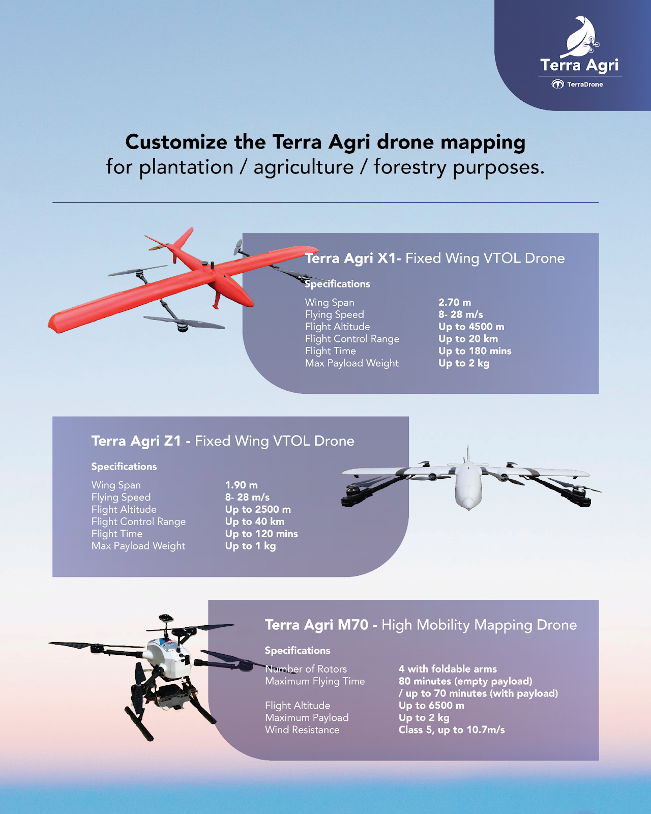
The two primary types of agriculture mapping drones are fixed-wing and multirotor. While both are suitable for mapping, the choice depends on specific needs. If an extended flight distance is crucial, a fixed-wing drone is preferable due to its longer flight time. Conversely, if the priority is carrying multiple payloads for mapping purposes, the multirotor drone, with its ample body space, becomes the better option. Here is a Terra Agri Mapping Drone sample you can use for mapping purposes.
The Basic Role of Drone in Mapping Area
Visualizing Crop Health
Agriculture drone mapping with a camera allows for the capture of expansive crop health images. This aids in visualizing and assessing the overall health of crops. By combining visual imagery with precision GPS maps, you can identify specific areas that require attention, facilitating prompt action in the field.
Creating Accurate 3D Models
The precision of drone mapping, calibrated for maximum accuracy, results in exact maps with reliable data. These agriculture mapping drone sensors precisely measure elevation changes, enabling the creation of accurate 3D models. These models, superior to those derived from traditional ground surveys, find versatile applications within agriculture.
Collecting Data in Challenging Spaces
Many crop fields have areas that are difficult to map using traditional methods, such as dense vegetation, steep slopes, or wetlands. Agriculture mapping drones excel in maneuvering through these challenging spaces, collecting high-resolution data like aerial photos and videos. Their flexibility allows for data collection in confined spaces, both indoors and within dense vegetation, aiding you in monitoring crops for diseases, pest damage, and other issues.
Determining the Optimal Harvest Time
A clear picture of crops progressing from seed to harvest is essential for ensuring a successful yield. In the past, you spent hours walking through fields, taking notes, and trying to track subtle changes over time. With agriculture mapping drones, you can obtain a clear and concise overview of their crops throughout their growth cycle, aiding in determining the best time to harvest.
Efficiently Covering Large Areas
One of the significant advantages of agriculture mapping drones is their ability to quickly and efficiently cover large areas. This eliminates the need for manual inspection of each field, saving time and providing more accurate and detailed results. The mapping drone surveys the entire area in less time, offering a comprehensive view of the agricultural landscape.
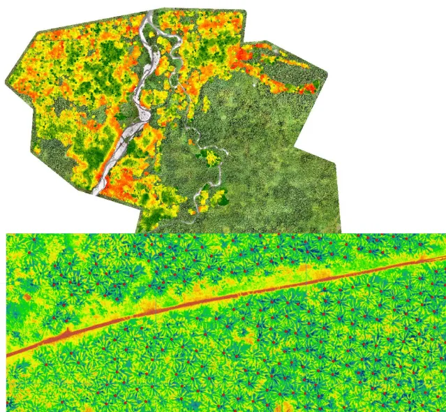
(Sample of Coconut tree counting and health detection. Photo Source Terra Agri documentation)
Mapping Outputs You Can Use a Drone
As drones continue to revolutionize topographic mapping, the outputs generated cater to various needs:
Digital Surface Model (DSM)
A topographical representation that includes both natural and artificial elements, excluding only what’s above the ground. DSMs provide a comprehensive view of the landscape.
Digital Elevation Model (DEM)
Specifically portraying the bare Earth’s topographic surface without the interference of trees, buildings, or other surface items. DEMs offer a clear depiction of the Earth’s natural elevation.
Digital Terrain Model (DTM)
A three-dimensional model focusing solely on altitude information, disregarding vegetation, buildings, and other features. DTMs provide insights into the Earth’s surface terrain.
Cross-Section DSM
Also known as a topographic profile or cross-section, it represents the topography along a longitudinal plane. These cross-sections are advantageous for showcasing changes in land structure along a designated line.
Contour Line 3D
Utilizing contour lines to depict a portion of the Earth’s surface, these lines create a visual representation of altitude above sea level or depth below sea level. Contour Line 3D models offer insights into the varying elevations of the landscape.
Point Cloud
Employing a laser tracking system to locate multiple pre-designated points in space, point cloud mapping translates this data into a virtual map. This technique is particularly useful for pinpointing specific features, such as linear building support or the location of new agricultural equipment.
Conclusion
In a nutshell, agriculture drone mapping is a top-notch tech tool in today’s farming. It helps see how crops are doing, make precise 3D models, and improve big-scale farming. The results, like Digital Surface Models and Elevation Models, give loads of info for smart decision-making based on data.
