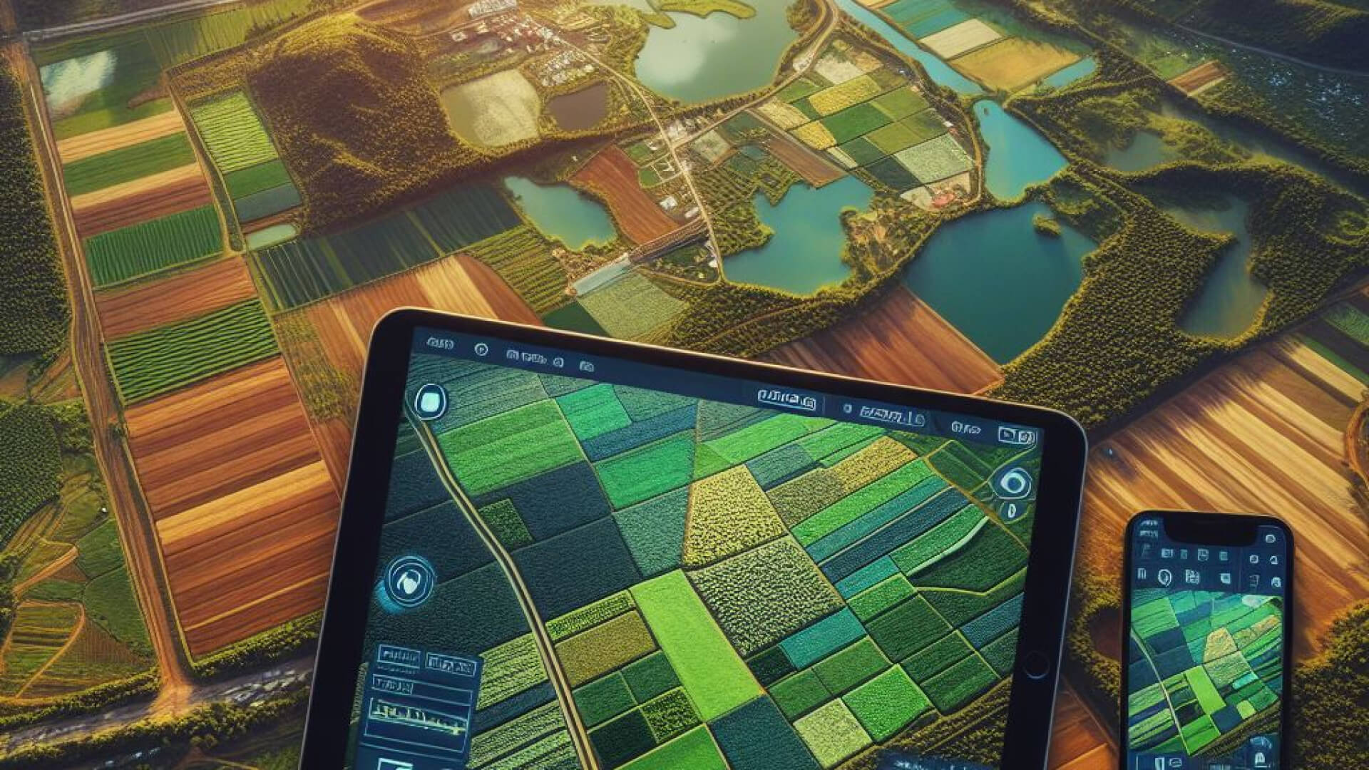
In the fast-paced and constantly evolving field of agriculture, new technologies are continuously being adopted to streamline processes and improve efficiency. One crucial technology driving this evolution is aerial imagery sensors, which play a pivotal role in agricultural activities such as spraying, mapping, and planting. Generally, aerial imagery in agriculture significantly advances understanding and managing agricultural landscapes. Here are some points highlighting the benefits of aerial imagery for agribusiness:
Advantages of Multispectral and Hyperspectral Imagery in Aerial Agriculture
Strategic Planning Enhanced
Aerial imagery is a pivotal tool for you, enriching their planning process with unparalleled views of their land. This wealth of detailed information facilitates strategic decision-making, ensuring that every acre is optimized for future agricultural endeavors. It’s about making informed choices that lead to efficient and productive farming practices.
Eco-Friendly and Economically Sound
In the quest for sustainability, aerial imagery emerges as a champion, promoting practices that are not only environmentally friendly but also economically savvy. Enabling precise land use and reducing the necessity for excessive agricultural inputs helps you balance profitability and ecological stewardship. This approach underscores the importance of resource conservation for future generations while attending to the immediate bottom line.
Ongoing Crop Health Surveillance
The health of crops is paramount, and aerial imagery offers a constant vigil, providing critical insights into the well-being of the fields below. This continuous monitoring capability allows for the early detection of potential issues, facilitating swift interventions. By catching problems early, you can mitigate risks, ensuring the vitality and abundance of their harvest.
Diverse Imaging for Diverse Needs
Within aerial imagery, two primary types stand out: multispectral and hyperspectral imagery. Each offers its advantages and is tailored to meet specific agricultural needs. Whether gaining a broad overview or analyzing the finer details of crop health, these technologies are reshaping the agricultural landscape, offering tools as diverse as the fields they survey.
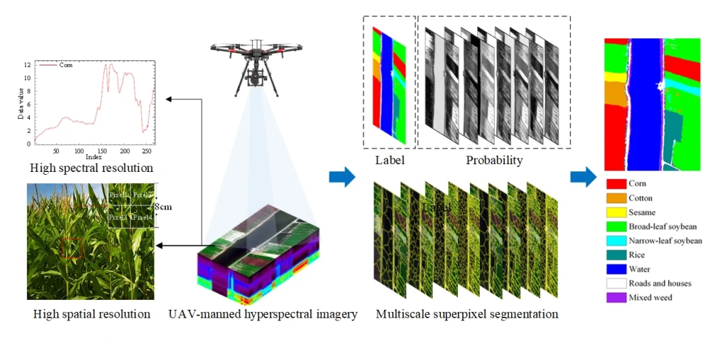
Image source Tian, S.; Lu, Q.; Wei, L. Multiscale Superpixel-Based Fine Classification of Crops in the UAV-Based Hyperspectral Imagery. Remote Sens. 2022, 14, 3292. https://doi.org/10.3390/rs14143292)
Understanding Multispectral and Hyperspectral Sensors
In aerial imagery technology, two standout processes are pivotal in agriculture: multispectral imagery and hyperspectral imagery. Each process has its unique workflow and specific applications, making them essential tools for modern farming practices. To give you a clearer insight, let’s dive into the differences between multispectral and hyperspectral imagery in agriculture, ensuring you understand how these technologies can be leveraged to enhance crop management and yield.
Multispectral Imagery
Multispectral imagery is a technology that captures objects’ reflectance across multiple electromagnetic spectrum bands. This type of imagery typically includes 5 to 10 bands, such as red, green, and blue (RGB), which are used to create color images. Standard multispectral sensors can collect data in the visible, near-infrared, and shortwave infrared bands. The applications of multispectral imagery in agriculture are diverse and impactful:
Advantages of Multispectral Imaging for Enhanced Crop Monitoring
1. Vegetation, Health and Vigor
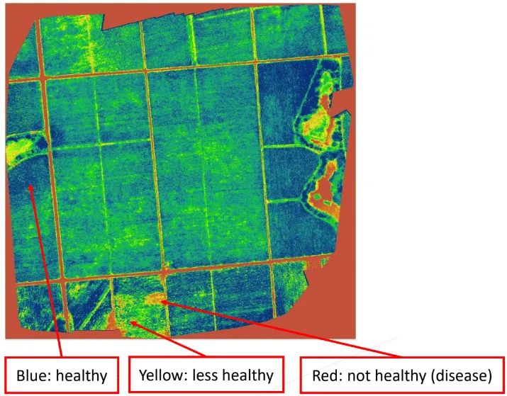
Multispectral imagery helps assess vegetation’s health and vigor by capturing and analyzing the reflected light from the plants. This information can detect stress, disease, or nutrient deficiencies in crops.
2. Crop Biomass and Yield Estimation
You can estimate crop biomass and predict yields by analyzing multispectral imagery. This data is crucial for making informed decisions related to agricultural practices and resource management.
3. Surface Classification
Multispectral imagery is used to classify different types of land surfaces, such as forested areas, based on their spectral signatures. This information is valuable for land use planning, conservation efforts, and environmental monitoring.
4. Environmental Analysis
In agriculture, multispectral imagery analyzes water quality, soil health, and geological features. It provides valuable insights into the environmental impact of agricultural activities and helps identify areas for improvement.
5. Hazardous Area Monitoring
Multispectral imagery can collect data from dangerous or inaccessible areas, allowing for remote monitoring of environmental conditions or hazards without putting personnel at risk.
Hyperspectral Imagery
Hyperspectral imagery (HSI) captures reflectance across a continuous range of wavelengths, offering higher spectral resolution than multispectral imagery. It typically includes hundreds of bands, covering a broader range of wavelengths, including invisible and short-wavelength infrared regions. Hyperspectral sensors can be tuned to specific wavelength ranges depending on the application, allowing for detailed chemical composition analysis of objects. Hyperspectral imagery is incredibly versatile and has a wide range of applications in agriculture:
The Benefits of Hyperspectral Imaging for Agribusiness
1. Tree Species Mapping
It can distinguish and map out various tree species within a forest, providing detailed insights into forest composition and health.
2. Surface Feature Identification
It can accurately identify and differentiate different features on the Earth’s surface, such as land use, soil variations, and geological formations.
3. Seed Viability Tracking
By analyzing reflectance spectra, hyperspectral imagery can effectively track and monitor the viability and health of seeds, aiding in agricultural planning and management.
4. Environmental Monitoring
It plays a crucial role in monitoring environmental factors by tracking surface CO2 emissions, mapping hydrological formations, and assessing pollution levels, contributing to effective environmental management and conservation efforts.
5. Agricultural Quality Control
It can detect and assess various quality aspects in agricultural produce, such as identifying bruises in apples, checking the freshness of fish, inspecting citrus fruits, mapping sugar distribution in melons, and sorting potatoes based on quality parameters.
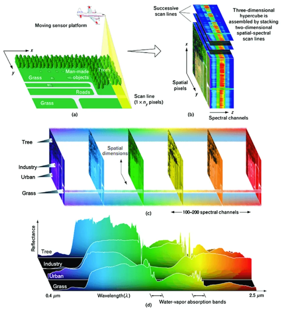
Image source: Sulaiman, N.; Che’Ya, N.N.; Mohd Roslim, M.H.; Juraimi, A.S.; Mohd Noor, N.; Fazlil Ilahi, W.F. The Application of Hyperspectral Remote Sensing Imagery (HRSI) for Weed Detection Analysis in Rice Fields: A Review. Appl. Sci. 2022, 12, 2570. https://doi.org/10.3390/app12052570)
Challenges in Implementing Multispectral and Hyperspectral Imagery in Precision Agriculture
Implementing multispectral and hyperspectral sensing technologies in agriculture comes with various challenges. Firstly, the high spatial and temporal resolutions these technologies offer demand advanced processing techniques to manage large datasets efficiently. Ensuring data accuracy involves radiometric correction, which addresses atmospheric conditions, sensor calibration, and geometric distortions.
Accurate spatial relationships between pixels are crucial, particularly for applications requiring precise spatial information, making geometric correction essential. These sensors must also integrate seamlessly with agricultural systems such as tractors, drones, and satellite platforms. Despite technological advancements, the cost of these sensors remains relatively high, making them less accessible, especially in developing regions.
Additionally, specialized expertise and software are necessary for accurate data interpretation and analysis, which can be a significant barrier for those who need these resources. Regular calibration and maintenance of the sensors are crucial to ensure data accuracy, posing challenges in remote or resource-constrained areas. Atmospheric conditions such as clouds, haze, and water vapor can interfere with data accuracy, necessitating careful consideration during data collection and processing.
Selecting and integrating the suitable sensor requires careful consideration of the spectral resolution, spatial resolution, and data processing capabilities. Finally, managing these technologies’ large volumes of data necessitates efficient data storage and management systems.
Conclusion
Understanding the differences between multispectral and hyperspectral imagery is vital, as this knowledge is crucial for making informed decisions in agricultural operations. Both technologies offer unique advantages and applications that can significantly enhance farm productivity and sustainability. Addressing the challenges associated with their implementation can help agribusinesses leverage these powerful tools to optimize their processes and drive innovation in the industry. If you are still trying to decide which aerial imagery method to use, let’s discuss it with Terra Agri. We provide agriculture mapping drone services to enhance your crop management.
