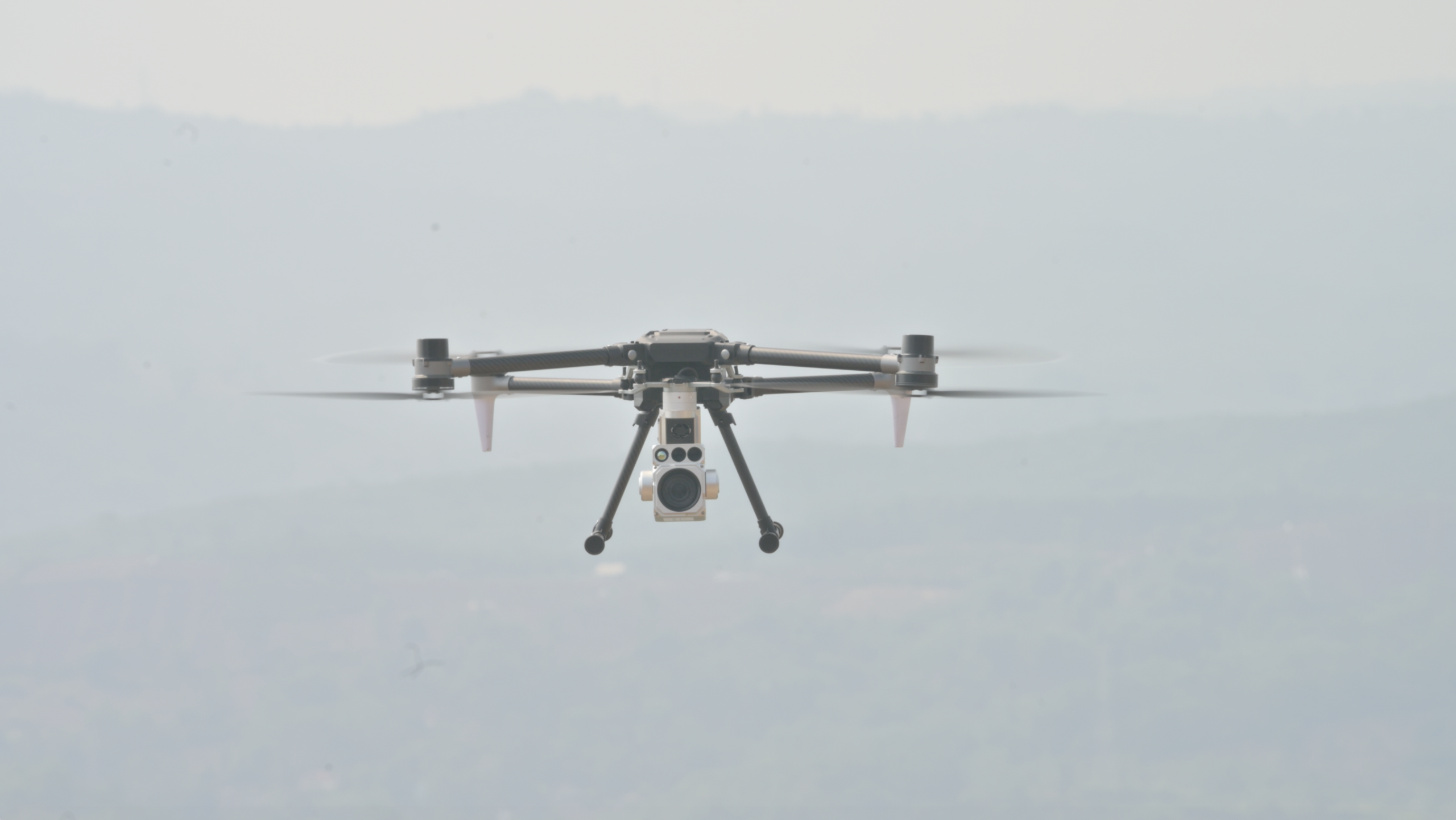
A thermal drone camera does not see light. It sees heat. That single distinction is why this technology can spot a water-stressed palm tree before its leaves ever change color, and it is also why it can find a person hiding in total darkness. This article breaks down exactly how a thermal drone camera works, starting with the physics of infrared radiation and moving through to the way plantations and security teams actually use the data it produces.
What Is a Thermal Drone Camera?
A thermal drone camera is an imaging sensor mounted on a drone that detects infrared radiation instead of visible light. Every object above absolute zero radiates heat as infrared energy, and since nearly everything on Earth sits well above that threshold, that means practically every object around us is constantly emitting it. A thermal drone camera captures that radiation and converts it into a visual image called a thermal image, where different colors or shades represent different temperatures.
This is fundamentally different from a standard RGB camera. An RGB camera needs reflected visible light to form a picture, so it fails in darkness, smoke, or thick haze. A thermal drone camera needs none of that, because it reads heat directly instead. As a result, it works at midnight just as well as it works at noon.
The Physics Behind Thermal Imaging
To understand a thermal drone camera, it helps to start with a basic principle of physics: all matter emits infrared radiation as a function of its temperature. This is called blackbody radiation, and it follows a predictable rule. The hotter an object is, the more infrared energy it emits, and consequently, the shorter the peak wavelength of that energy becomes.
Human eyes and standard cameras can only detect visible light, which is a narrow band of the electromagnetic spectrum. Infrared radiation sits just beyond that band, so it stays invisible to us even though it is very real. A thermal drone camera is built specifically to detect this invisible infrared radiation and translate it into something we can interpret visually.
This is also why a thermal drone camera can “see” a live animal in complete darkness, or detect a person hiding behind foliage. It is not detecting shape through light at all. Instead, it is detecting the infrared radiation the body itself is constantly emitting.
Inside a Thermal Drone Camera: Sensor and Optics
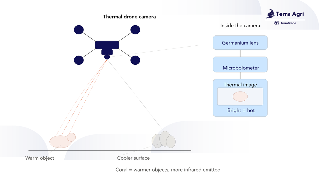
A thermal drone camera has two components that make this possible: a specialized lens and an infrared sensor.
The lens
Standard camera glass blocks most infrared radiation, so thermal cameras use lenses made from germanium instead of glass. Germanium is transparent to infrared wavelengths, so it allows the radiation to pass through cleanly and reach the sensor behind it.
The sensor
Most drone-mounted thermal cameras use an uncooled microbolometer as their infrared sensor. A microbolometer is a grid of thousands of tiny detector elements, and each one is sensitive to infrared radiation. When infrared energy hits an element, it causes a tiny, measurable change in that element’s electrical resistance. The camera then reads the resistance change across the entire grid and converts it into a temperature value for each pixel in the image.
This is the core mechanism behind every thermal drone camera on the market today. The sensor does not capture light at all. Rather, it captures a resistance change caused by heat, pixel by pixel, across the whole sensor array.
From Heat to Image: How the Sensor Builds a Picture
Once the microbolometer array collects its resistance data, onboard processing converts it into a viewable thermal image. This happens in two stages.
First, the raw resistance values are converted into a temperature map. In cameras capable of radiometric imaging, every single pixel carries an actual temperature value rather than just a relative brightness level. As a result, a radiometric thermal image is not just a picture but a dataset, so an operator can click on any point in the frame and read the exact temperature at that location.
Second, the temperature map is rendered into color for human interpretation. Because raw temperature data has no inherent color, thermal cameras apply a color palette to represent temperature differences visually. Common palettes include the following:
– White-hot, where brighter areas represent higher temperatures
– Black-hot, where darker areas represent higher temperatures instead, the inverse of white-hot
– Ironbow, a gradient from black through purple, red, orange, and yellow, widely used because it makes subtle temperature differences easy to distinguish
The strength of the color separation between adjacent temperatures is called thermal contrast. High thermal contrast makes it easy to spot a small temperature anomaly, such as a leaking pipe joint, an overheating motor, or a stressed plant, against a uniform background.
Resolution and Sensitivity: What Actually Matters
Two specifications define how good a thermal drone camera actually is, and neither one is obvious from a spec sheet at first glance.
Thermal resolution
Thermal resolution refers to the number of individual detector elements in the sensor array, expressed as width by height, for example 640×512. This figure is directly tied to pixel pitch, the physical size of each detector element. A smaller pixel pitch generally allows a higher resolution sensor to fit into the same physical size, which in turn improves the level of detail the camera can resolve from altitude.
NETD
NETD short for noise equivalent temperature difference, measures how small a temperature difference the sensor can reliably detect. A lower NETD value means finer sensitivity, so the camera can distinguish between two objects that differ by only a fraction of a degree rather than just spotting large temperature swings. For applications like early crop stress detection, where the temperature difference between a healthy leaf and a stressed one can be under one degree Celsius, NETD often matters more than raw resolution.
It helps to compare thermal resolution to visual camera resolution directly:
| Specification | Typical RGB drone camera | Typical thermal drone camera |
|---|---|---|
| Resolution | 4K (3840×2160) or higher | 640×512 or 320×256 |
| What it measures | Reflected visible light | Emitted infrared radiation |
| Works in darkness | No | Yes |
| Provides temperature data | No | Yes, if radiometric |
A thermal drone camera will almost always have lower pixel resolution than a visual camera on the same drone. That is not a flaw, though. It simply reflects the physical limits of infrared sensor manufacturing, and in practice, sensitivity as measured by NETD matters more than raw pixel count for most real-world use cases.
Thermal vs Visual vs Multispectral: Where Each One Fits
Agriculture drone operations increasingly carry more than one type of sensor, so it helps to know which tool answers which question.
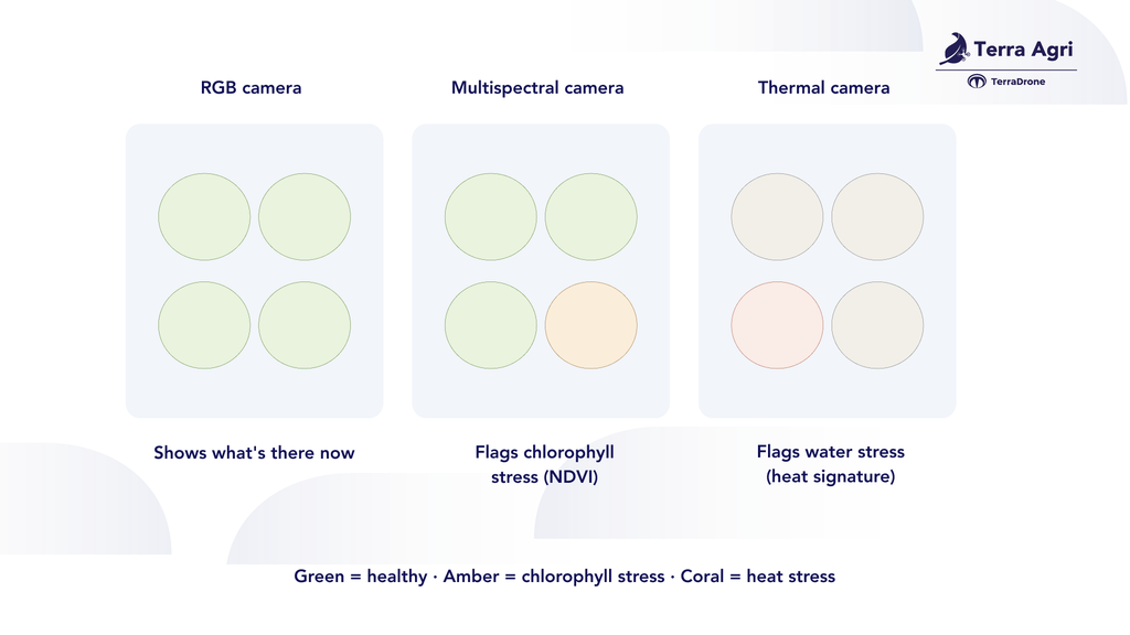
– A standard RGB camera shows what a crop looks like right now, including visible discoloration, canopy density, and weed patches
– A multispectral camera measures reflected light across specific wavelength bands, including near-infrared, to calculate vegetation indices like NDVI, which track plant health based on how leaves reflect light
– A thermal drone camera measures emitted heat instead, which reveals physiological stress, often before it becomes visible to the eye or shows up in reflectance data at all
These three sensor types are complementary rather than competing. A plantation running a full crop health program typically combines multispectral data for chlorophyll-related stress with thermal data for water-related stress, since the two forms of stress do not always show up at the same time.
How Thermal Drone Cameras Work in Agriculture
This is where thermal imaging becomes directly useful for a working plantation, not just an engineering curiosity.
Detecting water stress before it’s visible
A plant regulates its temperature largely through transpiration, the process of water evaporating from leaf pores called stomata. When a plant has enough water, transpiration cools the leaf surface. When a plant is water-stressed, however, its stomata close to conserve moisture, so transpiration slows and canopy temperature rises measurably, often days before the leaf visibly wilts or discolors. This relationship forms the basis of the crop water stress index (CWSI), a metric calculated from canopy temperature relative to ambient air temperature and humidity, which agronomists use to flag irrigation problems block by block.
Spotting pest and disease pressure early
Localized tissue damage from pests or pathogens frequently disrupts a plant’s normal transpiration pattern in that specific area, and this creates a small thermal anomaly against the surrounding healthy canopy. As a result, it becomes visible in a thermal image well before the naked eye would catch a change in leaf color.
Mapping drainage and irrigation issues
Standing water, waterlogged soil, and dry patches all carry distinct thermal signatures compared to normally irrigated ground, so it becomes straightforward to identify drainage problems across large blocks from the air rather than walking the perimeter on foot.
Livestock and wildlife monitoring
A living animal generates a strong, distinct heat signature against a cooler background of soil, foliage, or water, which is exactly what a thermal drone camera is built to pick up. This matters in two directions for a plantation. First, it makes it possible to survey grazing areas, count livestock, and check on animal welfare without physically walking every block, since a thermal drone camera can spot an animal through partial vegetation cover or well after dark, when a visual camera would return an empty-looking frame instead. Second, it flags wildlife intrusion early, since wild boar, elephants, and other animals that damage young palms or disturb operations tend to move at night or at dawn, right when visual monitoring is weakest and thermal monitoring is strongest. A single low-altitude pass over a boundary block can therefore confirm whether a heat signature is livestock, wildlife, or a person, well before anyone reaches the area on foot.
Fire and hotspot detection
This is one of the highest-stakes applications of thermal imaging for plantations in Indonesia and Malaysia, where peat soil is common and fire risk is a recurring operational concern. Peat fires frequently smolder underground for days before any smoke becomes visible at the surface, because the burn spreads slowly through organic material rather than open flame. A thermal drone camera detects the elevated surface temperature that these smoldering zones produce, essentially a genuine heat signature, long before a ground crew or a conventional camera would notice anything unusual. Flying a thermal drone camera over known peat-risk zones on a regular schedule therefore turns fire response from reactive, meaning responding once smoke is already visible, into proactive, meaning catching a hotspot while it is still small and containable. The same capability applies after a fire has been extinguished on the surface too: a thermal pass can confirm whether hidden embers remain in the peat layer, which is often where a fire that looked “out” reignites days later.
Thermal Drone Cameras for Surveillance
Beyond agriculture, the same underlying sensor technology also makes thermal drone cameras effective for perimeter and asset security.
A conventional surveillance drone camera depends on ambient or artificial light, so visibility drops sharply at night or in poor weather. A thermal drone camera sidesteps that limitation entirely, since it reads infrared radiation rather than reflected light. As a result, it becomes possible to detect a person’s heat signature through darkness, light fog, or partial vegetation cover, conditions where a standard visual camera would show almost nothing useful.
For a large estate boundary, this translates into a few concrete capabilities. It becomes possible to detect unauthorized entry along a perimeter at night without relying on fixed lighting infrastructure, to distinguish a human or vehicle heat signature from background vegetation even under partial concealment, and to cover large boundary lengths from the air far faster than a ground patrol could manage on foot or by vehicle.
Limitations Worth Knowing
A thermal drone camera is not a universal solution, so it helps to be upfront about where it falls short. Glass and most transparent surfaces block infrared radiation, so a thermal camera cannot see through windows or greenhouse panels. Rain and heavy fog can also scatter infrared radiation and reduce image clarity, similar to how they affect visible light. And because thermal resolution is lower than RGB resolution, fine surface detail such as text, small labels, or precise object edges is far easier to read in a standard visual image than in a thermal one.
None of these points are reasons to avoid the technology, though. Instead, they are reasons to pair a thermal drone camera with complementary sensors, which is exactly how most professional agriculture and surveillance drone operations are set up today.
Terra Model M1 (TMA1): Thermal Imaging Built for Surveillance and Inspection
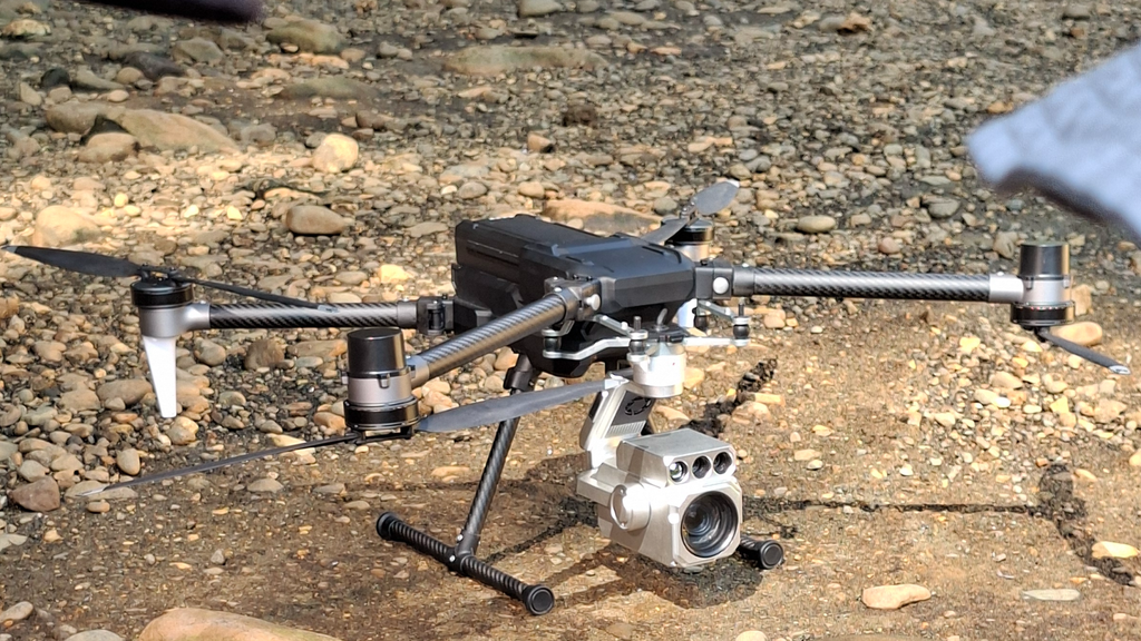
Everything explained above, from the microbolometer sensor to heat signature detection to the ability to see through darkness and partial cover, is exactly what powers the Terra Model M1 (TMA1), Terra Drone Agri’s dedicated surveillance and inspection platform.
The M1 pairs a 4K visual camera on a 3-axis gimbal with an integrated thermal imaging sensor, and the two are combined through a feature Terra Drone calls TrueSight AI. Rather than treating thermal imaging and object detection as separate tools, TrueSight AI layers them together. The thermal sensor first detects a heat signature in low-light, foggy, or nighttime conditions. An onboard AI model then identifies and classifies what that heat signature actually is, whether a person, a vehicle, or an animal, in real time. Smart tracking then locks onto the identified target and keeps it centered in frame automatically as it moves. For fire hotspot monitoring and wildlife or livestock detection specifically, this means an operator does not just get a warm blob on a thermal screen. Instead, they get a classified, tracked target with minimal manual interpretation required.
A few specifications are especially relevant to how the M1 performs in the field:
| Specification | Detail |
|---|---|
| Max payload | 2.5 kg |
| Max hover time | 90 min (unloaded) / 40 min (2.5 kg payload) |
| Max transmission distance | 10 km (omnidirectional antenna) / 15 km (directional antenna) |
| Fly speed | 18 m/s horizontal, 6 m/s ascent |
| Wind resistance | Up to 15 m/s |
| Operating temperature | -10°C to 50°C |
| Ingress protection | IP44 |
| Positioning | Dual RTK GNSS, horizontal/vertical hover accuracy of ±0.1 m |
| Visual camera | 4K, 3-axis gimbal, night vision capable |
The long hover time and 15 km directional transmission range matter directly for the use cases in this article. A 90-minute flight window is enough to cover a meaningful stretch of plantation boundary or a large peat-risk block in a single sortie, and the RTK-grade positioning accuracy means a detected hotspot or animal location can be logged precisely enough to send a ground team to the right spot without re-searching the area.
Contact our team to discuss a Terra Model M1 deployment scoped to your estate’s surveillance, fire monitoring, or wildlife management needs.