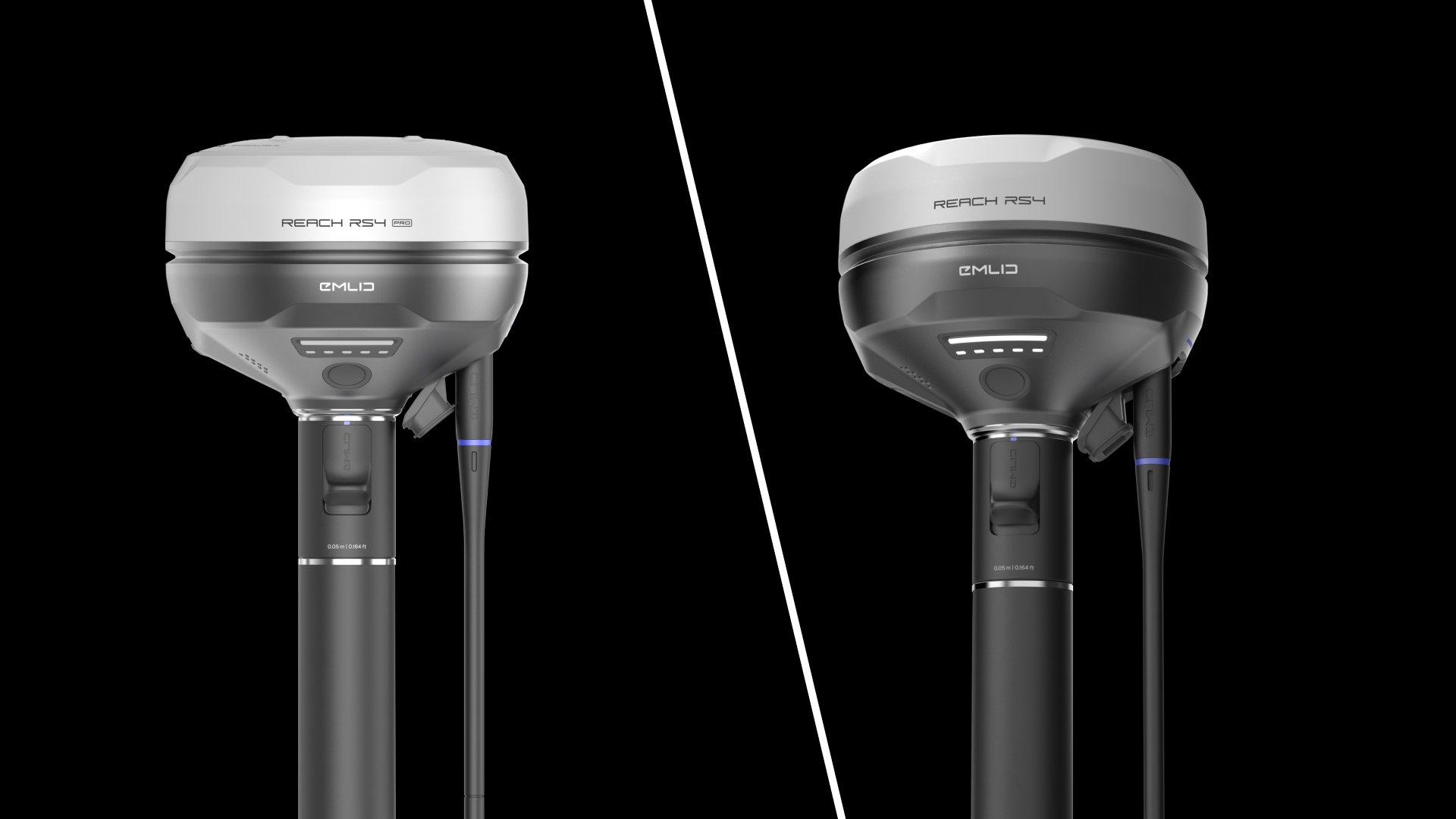
For agriculture drone operators, the Emlid Reach RS4 is the right receiver for most plantation work. The RS4 Pro has the same GNSS engine, tilt compensation, radios and battery, and adds dual cameras that matter mainly for estate construction and points your crew cannot reach. Boundary mapping, ground control and base station duty perform the same on both.
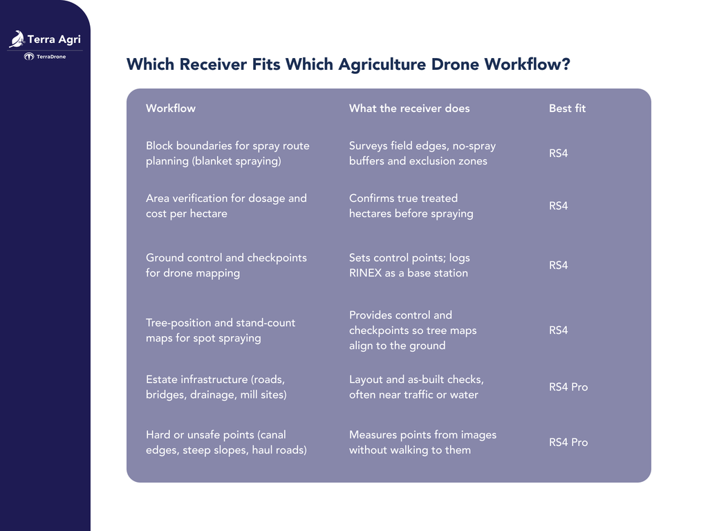
Which Receiver Fits Which Agriculture Drone Workflow?
RS4 vs RS4 Pro: What Is the Same and What Is Different?
The two receivers are far closer than the price gap suggests. Emlid launched both on 6 October 2025 as successors to the Reach RS3, and they share the same positioning hardware. Both reach 7 mm + 1 ppm horizontal and 14 mm + 1 ppm vertical accuracy in RTK mode, track 672 channels across L1, L2, L5 and L6, and use the same factory-calibrated tilt compensation (2 mm + 0.3 mm per degree, no angle limit, 5 to 10 seconds to initialize).
The rest of the package matches too. Each one can work as a base or a rover, logs RINEX to 16 GB of storage, and connects through Emlid Corrections, LoRa up to 1 W, UHF up to 2 W or NTRIP over LTE and Wi-Fi. They read and export NMEA, RTCM3, CSV, DXF and SHP, talk to TRIMTALK 450S radios, and share the same body: magnesium alloy, IP68, rated from -40 to +65 °C, with 16 hours of battery. That is a full day on an estate without a recharge.
What separates them is the cameras. The RS4 Pro has two Full-HD cameras that power AR stakeout and visual capture, and the RS4 has none. The Pro is also 16 g heavier (943 g against 927 g), which you will not notice on a survey pole. Emlid positions the RS4 for topo, drone mapping and rugged, forested sites, and the Pro for large-scale construction and hazardous sites. That is positioning, not a performance gap, because both deliver the same accuracy on the same ground. For current prices on either unit, request a quote from Terra Drone Agri.
How Does the Receiver Fit into Spray Drone Operations?
Spray drones carry their own RTK to position the aircraft. A ground receiver does a different job: it surveys the ground the drone will work on.
1. Boundaries and buffers
Mark block edges, waterways, settlements and neighboring crops so blanket-spray routes and no-spray zones are accurate to centimeters.
2. True hectares
Spray volume per hectare and chemical cost both depend on area. A boundary error of a few meters across a large block shifts the numbers.
3. Spot spraying
Tree-to-tree spot spraying relies on accurate tree maps. Surveyed control points keep those maps aligned with the ground, so the drone treats the right tree.
Blanket and spot spraying both start from the same surveyed base data. The RS4 covers all of it.
How Does the Receiver Fit into Drone Mapping and Monitoring?
NDVI, stand counts and canopy health maps are only comparable between flights if they sit on the same ground reference.
1. Ground control points. Use the RS4 as a rover to place and measure control points before the flight.
2. Base station. Set the RS4 as a base over a known point and log RINEX, or stream corrections to the rover over LoRa, UHF or NTRIP.
3. Under canopy. Tilt compensation lets the operator measure without leveling the pole. Dense oil palm canopy still weakens satellite signal, so fix times vary by block.
The cameras add nothing to these tasks, which is why the RS4 is the default choice for mapping teams.
When Does the RS4 Pro Make Sense on an Estate?
The Pro earns its premium when the work looks more like construction than farming.
AR stakeout
The design point or line appears on the live camera view with distance and direction cues, then the bottom camera gives a bullseye view near the target. This speeds up layout for roads, bridges, drainage and mill expansion, especially for newer operators.
Visual capture
The operator measures a point from images without standing on it, for example across an active haul road, along a canal edge or on an unstable slope. The receiver needs a FIX solution and tilt compensation enabled first.
Both tools depend on a good RTK fix. An image-based point is also not identical to placing the pole on the ground, so check Emlid’s documentation on expected accuracy at your working distance before using it for tight tolerances.
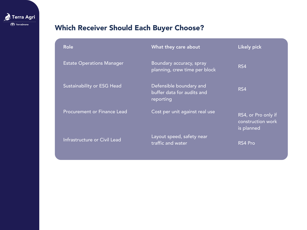
Which Receiver Should Each Buyer Choose?
Agribusiness purchases usually involve several decision makers.
Is the RS4 Pro Worth the Extra Cost?
Ask three questions.
1. Does your team regularly build or maintain roads, bridges, drainage or mill facilities that need stakeout?
2. Do crews often need to measure points they cannot safely walk to?
3. Do you need to shorten stakeout training for new operators?
If all three answers are no, buy the RS4. If one or more is yes, the Pro usually pays back in time saved and fewer people exposed to risk.
For a base and rover pair, a common setup is an RS4 as the base and an RS4 Pro as the rover, since a stationary base does not use cameras. Emlid also sells this combination as a kit.
Buy the Emlid Reach RS4 or RS4 Pro from Terra Drone Agri
Terra Drone Agri is an official Emlid distributor and runs agriculture drone services for plantations. Our team can match the receiver to your spray, mapping or estate survey workflow and support the setup.